Google is on an ambitious mission to map as much of the world as humanly possible. We recently reported on their project to photograph the tallest building in the world, and now they bring us to the shores of Hashima Island off the coast of Japan:
Also known as Gunkanjima, or “Battleship Island”, for its resemblance to the battleship Tosa, Hashima is a 16 square mile abandoned island which lays in the Amakusa-nada Sea, about 15 miles off the West coast of the Nagasaki Penninsula. It was purchased by Mitsubishi Group in 1890, at which point it was turned into a coal mine to fuel Japan’s industrial boom. At its peak, it housed over 5,000 inhabitants within its large, concrete apartments – buildings which were built to withstand Japan’s frequent typhoons. The mine was closed in 1974, as coal was replaced by oil, and it has since been completely abandoned – earning itself another nickname: “Ghost Island”.
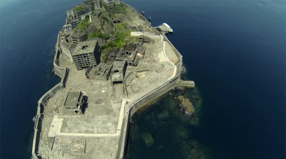
Over the years, the buildings have crumbled somewhat but largely held their shape; it has now become an architectural curiosity, and has been featured on television shows and in art exhibits. The Japanese government briefly considered turning it into a tourist destination, but halted plans when it was decided that the conditions were too unsafe.

Now, as the video shows, it serves as an icon of industrial decay, of human waste and blight, but also as a testament to nature’s relentless dominance. After only 35 years of abandonment, these buildings which were specifically engineered to keep nature’s violent will at bay have disintegrated as plants, trees, and grasses slowly reclaim the land. Thanks to Google Maps, every one of us (with internet access) can take a virtual tour of this half-living, half-dead world. It reminds us that human enterprise is fleeting, and though we can do nature much damage, she is indestructible and will ultimately dominate our fragile society, and all that we create.
You can explore Hashima yourself by navigating the map above. Google photographers mostly shoot with a specially-made 360-degree camera (the big blue thing on his back), but you’ll notice him using a Canon DSLR (most likely a 60D) with what appears to be a Sigma 8mm f/3.5 fisheye lens for some indoor shots. He uses a special tripod which holds the lens rather than the camera body, allowing him to achieve perfectly aligned panoramas.
Like This Article?
Don't Miss The Next One!
Join over 100,000 photographers of all experience levels who receive our free photography tips and articles to stay current:


BTW – the panohead is a 360Precision Atome, available for many camera/lens combos. Google Trusted Photographers can get a really sweet price on one from 360Precision.com .